Government and politics[edit]
Meghalaya's Governor is Tathagata Roy since August 2018.[46][47]
State government[edit]
The Meghalaya Legislative Assembly has 60 members at present. Meghalaya has two representatives in the Lok Sabha, one each from Shillong and Tura. It also has one representative in the Rajya Sabha.
Since the creation of the state the Gauhati High Court has jurisdiction in Meghalaya. A Circuit Bench of the Guwahati High Court has been functioning at Shillong since 1974. However recently in March 2013 the Meghalaya High Court was separated from the Gauhati High Court and now the state has its own High Court.
Local self-government[edit]
To provide local self-governance machinery to the rural population of the country, provisions were made in the Constitution of India; accordingly, the Panchayati Raj institutions were set up. However, on account of the distinct customs and traditions prevailing in the northeast region, it was felt necessary to have a separate political and administrative structure in the region.[citation needed] Some of the tribal communities in the region had their own traditional political systems, and it was felt that Panchayati Raj institutions may come into conflict with these traditional systems. The Sixth Schedule was appended to the Constitution on the recommendations of a subcommittee formed under the leadership of Gopinath Bordoloi, and the constitution of Autonomous District Councils (ADCs) is provided in certain rural areas of the northeast including areas in Meghalaya. The ADCs in Meghalaya are the following:
Economy[edit]
Meghalaya is predominantly an agrarian economy. Agriculture and allied activities engage nearly two-thirds of the total workforce in Meghalaya. However, the contribution of this sector to the State's NSDP is only about one-third. Agriculture in the state is characterised by low productivity and unsustainable farm practices. Despite the large percentage of the population engaged in agriculture, the state imports food from other Indian states.[citation needed] Infrastructural constraints have also prevented the economy of the state from creating high-income jobs at a pace commensurate with that of the rest of India.
Meghalaya's gross state domestic product for 2012 was estimated at ₹16,173 crore (US$2.3 billion) in current prices.[10] As of 2012, according to the Reserve Bank of India, about 12% of total state population is below poverty line, with 12.5% of the rural Meghalaya population is below the poverty line; while in urban areas, 9.3% are below the poverty line.[48]
Agriculture[edit]

Tea Plantation in Meghalaya, on the way to Shillong
Meghalaya is basically an agricultural state with about 80% of its population depending entirely on agriculture for their livelihood. Nearly 10% of the geographical area of Meghalaya is under cultivation. Agriculture in the state is characterised by limited use of modern techniques, low yields, and low productivity. As a result, despite the vast majority of the population being engaged in agriculture, the contribution of agricultural production to the state's GDP is low, and most of the population engaged in agriculture remain poor. A portion of the cultivated area is under the traditional shifting agriculture known locally as Jhum cultivation.
Meghalaya produced 230,000 tonnes of food grains in 2001. Rice is the dominant food grain crop accounting for over 80% of the food grain production in the state. Other important food grain crops are maize, wheat, and a few other cereals and pulses. Besides these, potato, ginger, turmeric, black pepper, areca nut, Bay leaf (Cinnamomum tamala), betel, short-staple cotton, jute, mesta, mustard and rapeseed etc. are some of the important cash crops. Besides the major food crops of rice and maize, the state is renowned for its horticultural crops like orange, lemon, pineapple, guava, litchi, banana, jack fruits and fruits such as plum, pear, and peach.[49]

Agriculture in Kukon, Meghalaya
Grains and staples production covers about 60% of the land area dedicated to crops. With the introduction of different crops of high yielding varieties in the mid-1970s, a remarkable increase in food grain production has been made. A major breakthrough was achieved when high yielding varieties of paddy[50] such as Masuri, Pankaj IR 8, RCPL and other improved varieties series – especially IR 36 which is suitable for Rabi season – allowing three crops to be grown every year. Another milestone was reached when Megha I and Megha II, which are cold tolerant rice varieties developed by the ICAR North East Region at Umroi near Shillong, was released in 1991–92 for the higher altitude regions where there was no high yielding rice varieties earlier. Today the state can claim that about 42% area under paddy has been covered with high yielding varieties with the average productivity of 2,300 kg/ha (2,100 lb/acre). As is the case with maize and wheat where the productivity have increased tremendously with the introduction of HYV from 534 kg/ha (476 lb/acre) during 1971–72 to 1,218 kg/ha (1,087 lb/acre) of maize and from 611 kg/ha (545 lb/acre) to 1,490 kg/ha (1,330 lb/acre) of wheat.[51]
Oilseeds such as rapeseed, mustard, linseed, soybean, castor, and sesame are grown on nearly 100 km2 (39 sq mi). Rape and mustard are the most important oilseeds[52] accounting for well over two-thirds of the oilseed production of nearly 6.5 thousand tonnes. Fiber crops such as cotton, jute, and mesta are among the only cash crops in Meghalaya, grown in Garo Hills.[53] These have been losing popularity in recent years as indicated by their declining yield and area under cultivation.
Climatic conditions in Meghalaya permit a large variety of horticulture crops including fruits, vegetables, flowers, spices, mushrooms, and medicinal plants.[49] These are considered to be higher value crops, but home food security concerns have prevented farmers at large from embracing them. The important fruits grown include citrus fruits, pineapples, papayas, and bananas. In addition to this, a large variety of vegetables are grown in the state, including cauliflower, cabbages, and radishes.
Areca nut plantations can be seen all over the state, especially around the road from Guwahati to Shillong. Other plantation crops like tea, coffee and cashews have been introduced lately and are becoming common. A large variety of spices, flowers, medicinal plants and mushrooms are grown in the state.
Industry[edit]

View of MCL Cement plant, Thangskai, P.O. Lumshnong, Jaintia Hills
Meghalaya has a rich base of natural resources. These include minerals such as coal, limestone, sillimanite, Kaolin and granite among others. Meghalaya has a large forest cover, rich biodiversity, and numerous water bodies. The low level of industrialisation and the relatively poor infrastructure base acts as an impediment to the exploitation of these natural resources in the interest of the state's economy. In recent years two large cement manufacturing plants with production capacity more than 900 MTD have come up in Jaintia Hills district and several more are in pipeline to use the rich deposit of very high-quality limestone available in this district.
Electricity infrastructure[edit]

Meghalaya has abundant but undeveloped hydroelectric resources. Above is Mawphlang hydroelectric dam reservoir.
Meghalaya with its high mountains, deep gorges, and abundant rains has a large, unused hydroelectric potential. The assessed generation capacity exceeds 3000 MW. The current installed capacity in the state is 185 MW, but the state itself consumes 610 MW. In other words, it imports electricity.[54] The economic growth of the state suggests rising demand for electricity. The state has the potential to export net hydroelectric-generated electricity and earn income for its internal development plans. The state also has large deposits of coal, thus being a candidate for thermal power plants.
Several projects are under works. The proposed Garo Hills thermal project at Nangalbibra is expected to generate an additional 751 MW of power. There is a proposal for setting up a 250 MW thermal power plant in West Khasi Hills. The State Government aims to increase its power generation output by about 2000-2500 MW, of which 700-980 MW will be thermal based while 1400-1520 MW will be hydroelectricity. The State Government has outlined a cost-shared public-private partnership model to accelerate private sector investments in its power sector.[55] The generation transmission, transformation and distribution of electricity is entrusted to the Meghalaya Energy Corporation Limited which was constituted under the Electricity Supply Act, 1948. At present, there are five hydel power stations and one mini hydel including Umiam Hydel Project, Umtrew Hydel Project, Myntdu-Leshka-I Hydel Project, and the Sunapani Micro Hydel (SESU) Project.
For the 12th five-year plan of India, there is a proposal to set up more hydel power projects in the state: Kynshi (450 MW), Umngi −1 (54 MW), Umiam-Umtru -V (36 MW), Ganol (25 MW), Mawphu (120 MW), Nongkolait (120 MW), Nongnaw (50 MW), Rangmaw (65 MW), Umngot (260 MW), Umduna (57 MW), Myntdu-Leshka-II (60 MW), Selim (170 MW) and Mawblei (140 MW).[56] Of these, Jaypee Group has committed itself to building the Kynshi and Umngot projects in Khasi hills.[57]
Education infrastructure[edit]

St. Edmund's School, Shillong
Meghalaya had a literacy rate of 62.56 as per the 2001 census and is the 27th most literate state in India. This increased to 75.5 in 2011. As of 2006, the state had 5851 primary schools, 1759 middle schools, and 655 higher secondary schools respectively. In 2008, 518,000 students were enrolled in its primary schools, and 232,000 in upper primary schools. The state monitors its school for quality, access, infrastructure and teachers training.[58]
Institution for higher studies like Indian Institute of Management, the University of Technology and Management (USTM) which is in Shillong is the first Indian university to introduce cloud computing engineering as a field of study, in collaboration with IBM and the University of Petroleum and Energy Studies. IIM Shillong is one of the top ranked management institutes in the country.[59]
Health infrastructure[edit]
The state has 13 state government dispensaries, 22 community health centres, 93 primary health centres, 408 sub-centers. There were 378 doctors, 81 pharmacists, 337 staff nurses and 77 lab technicians as of 2012. A special program has been launched by the state government for the treatment of tuberculosis, leprosy, cancer and mental diseases. Though there has been a steady decline in the death rate, improvement in life expectancy and an increase in health infrastructure, about 42.3% of the state's population is still uncovered by health care, according to the status paper prepared by the Health Department. There are numerous hospitals being set up, both private and government, some of them are Civil Hospital, Ganesh Das Hospital, K.J.P. Synod Hospital, NEIGRIHMS, North Eastern Institute of Ayurveda & Homoeopathy (NEIAH), R P Chest Hospital, Wood Land Hospital, Nazareth Hospital, Christian Hospital etc.
Urban areas[edit]
- Municipalities: Shillong, Tura, Jowai
- Municipal boards: Williamnagar, Resubelpara, Baghmara
- Cantonment board: Shillong Cantonment (Umroi)
- Town committees: Nongstoin, Nongpoh, Mairang
- Census towns: Mawlai, Madanrting, Nongthymmai, Nongmynsong, Pynthorumkhrah, Sohra/Cherrapunjee, Pynursla
- Minor towns: Khliehriat, Mawkyrwat, Ampati
- Areas under Shillong Urban Agglomeration: Shillong, Shillong Cantonment/Umroi, Mawlai, Madanrting, Nongthymmai, Nongmynsong, Pynthorumkhrah
New proposal for urban areas[edit]
- Municipal corporations: Shillong (including Shillong Cantonment/Umroi, Mawlai, Madanrting, Nongthymmai, Nongmynsong, Pynthorumkhrah)
- Municipalities: Tura, Jowai, Williamnagar
- Municipal boards: Resubelpara, Baghmara, Nongstoin, Nongpoh, Mairang, Khliehriat, Mawkyrwat, Ampati, Sohra/Cherrapunjee
- Town committees: Pynursla
Culture and society[edit]
The main tribes in Meghalaya are the Khasis, the Garos, and the Jaintias. Each tribe has its own culture, traditions, dress, and language.
Social institutions[edit]
The majority of the population and the major tribal groups in Meghalaya follow a matrilineal system where lineage and inheritance are traced through women. The youngest daughter inherits all the property and she is the caretaker of aged parents and any unmarried siblings.[8] In some cases, such as when there is no daughter in the family or other reasons, the parents may nominate another girl such as a daughter in law as the heir of the house and all other property they may own.
The Khasi and Jaintia tribesmen follow the traditional matrilineal norm, wherein the Khun Khatduh (or the youngest daughter) inherits all the property and responsibilities for the family. However, the male line, particularly the mother's brother, may indirectly control the ancestral property since he may be involved in important decisions relating to property including its sale and disposal. In case a family has no daughters, the Khasi and Jaintia (also called Syntengs) have the custom of ia rap iing, where the family adopts a girl from another family, perform religious ceremonies with the community, and she then becomes ka trai iing (head of the house).[60]
In the Garo lineage system, the youngest daughter inherits the family property by default, unless another daughter is so named by the parents. She then becomes designated as nokna meaning 'for the house or home'. If there are no daughters, a chosen daughter-in-law (bohari) or an adopted child (deragata) comes to stay in the house and inherit the property.
Meghalaya has one of the world's largest surviving matrilineal cultures.
Meghalaya "Civil Society"[edit]
Meghalaya's civil society considers the people of the state as a collective community that exists through civil society organisations (CSOs), and serves the general interests of the public.[61] These organisations include a wide spectrum of non-government organisations (NGOs), other community associations, and foundations. The current status of Meghalaya's civil society and the effectiveness of the many programs is debated by scholars.
Civil Society Programs in Meghalaya[edit]
There are currently over 181 NGOs within Meghalaya that vary from charities to volunteer services and social empowerment groups[62] .[63] Most civil society organisations are also ethnically affiliated as the interests of different groups are championed between each organisation . This in turn causes them to become representatives of ethnic communities around the state since the same individuals from such communities also participate in corresponding organisations that protect their ethnic interests. Three student organisations that represent the major ethnic groups of Meghalaya: Khasi Students' Union (KSU), Jantia Students' Union (JSU), and Garo Students' Union (GSU) embody this example into their overall functions as CSOs by applying pressure to local government in order to ensure that certain rights are being met.[61]
There also exists many forms of community associations that revolve around the idea of community building. This includes examples such as sports, religious, educational, and other clubs that aim to establish individuals into different social circles based on their interests.[63]
Philanthropic foundations in Meghalaya's civil society strive for the overall well being of its citizens. The Public Health Foundation of India (PHFI) has recently partnered with the government of Meghalaya to improve public health in many rural parts of the state by first strengthening the abilities of non-government organisations to perform such services.[64]
Civil Society: Current Status and Scholarly Debates[edit]
Scholars are divided on the effectiveness Meghalaya's civil society. Some argue for its important role in state development through CSOs, while others point out that their impact is not only limited from above by the central government and its military, but also from below by insurgent groups .[65]
Concerns over national security, such as the unification of neighbouring hostile countries and local insurgent groups for a possible attack on the Indian state, has served as the longstanding point of emphasis on how the Indian Central Government operates in the Northeast. Different administrative programs have been created to establish peace and stability in this region through economic development.[66] The Armed Forces Special Powers Act (AFSPA) that was passed in 1958 by the Indian Government granted the Indian Army exclusive powers to maintain order in this area. Many insurgent organisations were also developed alongside cultural and political movements, making it very difficult to distinguish them from what constitutes a civil society.[65] These two factors have combined to enable CSOs to be easily deemed as insurgencies and grouped with other insurgent organisations that were banned by the government, thus restricting Meghalaya's civil society as a whole.[65][67]
Traditional political institutions[edit]
All the three major ethnic tribal groups, namely, the Khasis, Jaintias and the Garos also have their own traditional political institutions that have existed for hundreds of years. These political institutions were fairly well developed and functioned at various tiers, such as the village level, clan level, and state level.[68]
In the traditional political system of the Khasis, each clan had its own council known as the Dorbar Kur which was presided over by the clan headman. The council or the Dorbar managed the internal affairs of the clan. Similarly, every village had a local assembly known as the Dorbar Shnong, i.e. village Durbar or council, which was presided over by the village headman. The inter-village issues were dealt with through a political unit comprising adjacent Khasi Villages. The local political units were known as the raids, under by the supreme political authority is known as the Syiemship. The Syiemship was the congregation of several raids and was headed an elected chief known as the Syiem or Siem (the king).[68] The Siem ruled the Khasi state through an elected State Assembly, known as the Durbar Hima. The Siem also had his mantris (ministers) whose counsel he would use in exercising executive responsibilities. Taxes were called pynsuk, and tolls were called khrong, the latter being the primary source of state income. In the early 20th century, Raja Dakhor Singh was the Siem of Khymir.[68]
Meghalaya
festival[69] | Local
calendar month | Vedic
calendar month | Gregorian
calendar month |
|---|
| Den'bilsia | Polgin | Phalgun | February |
| A'siroka | Chuet | Chaitra | March |
| A' galmaka | Pasak | Vaisakha | April |
| Miamua | Asal | Asharha | June |
| Rongchugala | Bado | Bhadra | August |
| Ahaia | Asin | Ashwin | September |
| Wangala | Gate | Kartika | October |
| Christmas | Posi | Pausha | December |
The Jaintias also had a three-tier political system somewhat similar to the Khasis, including the Raids and the Syiem.[70] The raids were headed by Dolois, who were responsible for performing the executive and ceremonial functions at the Raid level. At the lowest level were the village headmen. Each administrative tier had its own elected councils or durbars.
In the traditional political system of the Garos a group of Garo villages comprised the A·king. The A·king functioned under the supervision of the Nokmas, which was perhaps the only political and administrative authority in the political institution of the Garos. The Nokma performed both judicial and legislative functions. The Nokmas also congregated to address inter-A·king issues. There were no well-organised councils or durbars among the Garos.[citation needed]
Festivals[edit]
- Khasis
Dance is central to the culture of Khasi life, and a part of the rites of passage. Dances are performed in Shnong (village), a Raid (group of villages), and a Hima (conglomeration of Raids). Some festivals includes Ka Shad Suk Mynsiem, Ka Pom-Blang Nongkrem, Ka-Shad Shyngwiang-Thangiap, Ka-Shad-Kynjoh Khaskain, Ka Bam Khana Shnong, Umsan Nongkharai, Shad Beh Sier.[69]
- Jaintias
Festivals of the Jaintia Hills, like others, is integral to the culture of people of Jaintia Hills. It celebrates nature, balance and solidarity among its people. Festivals of Jaintias includes Behdienkhlam, Laho Dance, Sowing Ritual Ceremony.[69]
- Garos
For Garos, festivals sustain their cultural heritage. They were often dedicated to religious events, nature and seasons as well as community events such as stages of jhum cultivation. The main festivals of Garos are Den Bilsia, Wangala, Rongchu gala, Mi Amua, Mangona, Grengdik BaA, Jamang Sia, Ja Megapa, Sa Sat Ra Chaka, Ajeaor Ahaoea, Dore Rata Dance, Chambil Mesara, Do'KruSua, Saram Cha'A, A Se Mania or Tata which celebrated .[69]
- Hajongs
Hajongs celebrate both traditional festivals and Hindu festivals. The entire plain belt of Garo Hills is inhabited by the Hajongs, they are an agrarian tribe. Major traditional festivals include Pusne', Biswe', Kati Gasa, Bastu Puje' and Chor Maga.
- Biates
The Biates have many kinds of festivals; Nûlding Kût, Pamchar Kût, Lebang Kût, Favang Kût etc. for different occasion. However, unlike in the past, they no longer practise or observe those festivals except ‘Nûlding Kût.’ The Nûlding Kût ("renewal of life") festival is observed every January, with singing, dancing, and traditional games—after the Priest (Thiampu) pray to Chung Pathian to bless them in every sphere of life.
Spirituality[edit]
In southern Meghalaya, located in Mawsynram, is the Mawjymbuin cave. Here a massive stalagmite has been shaped by nature into a Shivalinga. According to legend, from the 13th century, this Shivalinga (called Hatakeswarat) has existed in the Jaintia Hills under the reign of Ranee Singa. Tens of thousands of the Jaintia tribe members participate over the Hindu festival of Shivratri (Night of Lord Shiva) every year.[73]
Living Root Bridges[edit]
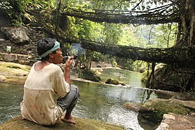
Double-Decker Living root bridge, Nongriat village.
The practice of creating Living root bridges can be found in Meghalaya. Here, functional, living, architecture is created by slowly training the Aerial roots of the Ficus elastica tree. Examples of these structures can be found as far west as the valley east of Mawsynram,[74] and as far east as the East Jaintia Hills District,[75] meaning that they are made by both Khasis and Jaintias. Large numbers[76] of these man-made living structures exist in the mountainous terrain along the southern border of the Shillong Plateau, though as a cultural practice they are fading, with many individual examples having disappeared recently, either falling in landslides or floods or being replaced with more standard steel bridges.[77]
Transport[edit]
The partition of the country in 1947 created severe infrastructural constraints for the Northeastern region, with merely 2% of the perimeter of the region adjoining the rest of the country. A narrow strip of land often called the Siliguri Corridor or the Chicken's Neck, connects the region with the state of West Bengal. Meghalaya is a landlocked state with many small settlements in remote areas. The road is the only means of transport. While the capital Shillong is relatively well connected, road connectivity in most other parts is relatively poor. A significant portion of the roads in the state is still unpaved. Most of the arrivals into the Meghalaya take place through Guwahati in neighbouring Assam, which is nearly 103 km away. Assam has a major railhead as well as an airport with regular train and air services to the rest of the country.
When Meghalaya was carved out of Assam as an autonomous state in 1972, it inherited a total road length of 2786.68 km including 174 km of National Highways with road density of 12.42 km per 100 square kilometre. By 2004, total road length has reached up to 9,350 km out of which 5,857 km were surfaced. The road density had increased to 41.69 km per 100 square kilometre by March 2011. However, Meghalaya is still far below the national average of 75 km per 100 km2. To provide better services to the people of the state, the Meghalaya Public Works Department is taking steps for improvement and up-gradation of the existing roads and bridges in phased manner.[44]
State Highway 5 near Cherapunjee, Meghalaya
Road network[edit]
Meghalaya has a road network of around 7,633 km, out of which 3,691 km is black-topped and the remaining 3942 km is gravelled. Meghalaya is also connected to Silchar in Assam, Aizawl in Mizoram, and Agartala in Tripura through national highways. Many private buses and taxi operators carry passengers from Guwahati to Shillong. The journey takes from 3 to 4 hours. Day and night bus services are available from Shillong to all major towns of Meghalaya and also other capitals and important towns of Assam and the northeastern states.
Railway[edit]
Meghalaya has a railhead at Mendipathar and regular train service connecting Mendipathar in Meghalaya and Guwahati in Assam, has started on 30 November 2014.[78] The Cherra Companyganj State Railways was a former mountain railway through the state.[79] Guwahati (103 kilometres (64 mi) from Shillong) is the nearest major railway station connecting the north-east region with the rest of the country through a broad gauge track network. There is a plan for extending the rail link from Guwahati to Byrnihat (20 kilometres (12 mi) from Guwahati) within Meghalaya and further extending it up to state capital Shillong.
Aviation[edit]
State capital Shillong has an airport at Umroi 30 kilometres (19 mi) from Shillong on the Guwahati-Shillong highway. A new terminal building was built at a cost of ₹30 crore (US$4.2 million) and inaugurated in June 2011.[80] Air India Regional operates flights to Kolkata from this airport. There is also a helicopter service connecting Shillong to Guwahati and Tura. Baljek Airport near Tura became operational in 2008.[81] The Airports Authority of India (AAI) is developing the airport for operation of ATR 42/ATR 72 type of aircraft.[82] Other nearby airports are in Assam, with Borjhar, Guwahati airport (IATA: GAU), about 124 kilometres (77 mi) from Shillong.
Tourism[edit]

Umiam Lake, Shillong, Meghalaya, India
Earlier, foreign tourists required special permits to enter the areas that now constitute the state of Meghalaya. However, the restrictions were removed in 1955. Meghalaya is compared to Scotland for its highlands, fog, and scenery.[8] Meghalaya has some of the thickest primary forests in the country and therefore constitutes one of the most important ecotourism circuits in India. The Meghalaya subtropical forests support a vast variety of flora and fauna. Meghalaya has 2 National Parks and 3 Wildlife Sanctuaries.
Meghalaya also offers many adventure tourism opportunities in the form of mountaineering, rock climbing, trekking, and hiking, caving (spelunking) and water sports. The state offers several trekking routes, some of which also afford an opportunity to encounter rare animals. The Umiam Lake has a water sports complex with facilities such as rowboats, paddleboats, sailing boats, cruise-boats, water-scooters, and speedboats.
Cherrapunji is a tourist destination in north-east of India. It lies to the south of the capital Shillong. A rather scenic 50-kilometre long road connects Cherrapunji with Shillong.[{fact}}
Living root bridges are also a tourist draw, with many examples located near Cherrapunji.[83] The Double-Decker root bridge, along with several others, is found in the village of Nongriat, which is tourist friendly. Many other root bridges can be found nearby, in the villages of Nongthymmai, Mynteng, and Tynrong.[74] Other areas with root bridges include Riwai village, near the tourist village of Mawlynnong, Pynursla, especially the villages of Rangthyllaing and Mawkyrnot, and the area around Dawki, in the West Jaintia Hills district, where there are many living root bridges scattered throughout the nearby villages.[75]
- Waterfalls and rivers
Multiple drops of Nohkalikai Falls Main drop of Nohkalikai Falls The most visited waterfalls in the state include the Elephant Falls, Shadthum Falls, Weinia falls, Bishop Falls, Nohkalikai Falls, Langshiang Falls and Sweet Falls.[citation needed] The hot springs at Jakrem near Mawsynram are believed to have curative and medicinal properties.
Nongkhnum Island located in the West Khasi Hills district is the biggest river island in Meghalaya and the second biggest in Asia. It is 14 kilometres from Nongstoin. The island is formed by the bifurcation of Kynshi River into the Phanliang River and the Namliang River. Adjacent to the sandy beach the Phanliang River forms a lake. The river then moves along and before reaching a deep gorge, forms a waterfall about 60 meters high called Shadthum Fall.
- Sacred groves
Meghalaya is also known for its "sacred groves". They are small or large areas of forests or natural vegetation that are usually dedicated to local folk deities or tree spirits or some religious symbolism over many generations, often since ancient times. These spaces are found all over India, are protected by local communities, and in some cases, the locals would neither touch leaves or fruits or in other ways damage the forest, flora or fauna taking refuge in them. This guardianship creates a sacred area where nature and wildlife thrive. The Mawphlang sacred forest, also known as "Law Lyngdoh," is one of the most famous sacred forests in Meghalaya. It's located about 25 kilometres from Shillong. It's a scenic nature destination, and one can find the sacred Rudraksha tree here.[85]
- Rural areas
Meghalaya rural life and villages offer a glimpse in northeast mountain life.[tone] The Mawlynnong village located near the India-Bangladesh border is one such village. It has been featured by travel magazine Discover India.[86] The village is geared for tourism and has a Living Root Bridges, hiking trails and rock formations.
Umaim lake (top) and scenery near Shillong.
- Lakes
Meghalaya also has many natural and manmade lakes. The Umiam Lake (popularly known as Bara Pani meaning Big water) on the Guwahati-Shillong road is a major tourism attraction for tourist. Meghalaya has several parks; Thangkharang Park, the Eco-park, the Botanical Garden and Lady Hydari Park to name a few. Dawki, which is located at about 96 Kilometres from Shillong is the gateway to Bangladesh and affords a scenic view of some of the tallest mountain ranges in Meghalaya and the Bangladesh borderlands.
Thadlaskein Lake also Pung Sajar Nangli is the only historical Lake of Meghalaya. It is located besides National Highway 6 by the side of a small village called Mukhla village which falls under West Jaintia Hills district Jowai. It is about 35 mile from the city of Shillong
Balpakram National Park with its pristine habitat and scenery is a major attraction.[87] The Nokrek National Park, also in Garo Hills has its own charm with a lot of wildlife.[88]
- Caves
Meghalaya has an estimated 500 natural limestone and sandstone caves spread over the entire state including most of the longest and deepest caves in the sub-continent. Krem Liat Prah is the longest cave, and Synrang Pamiang is the deepest cave. Both are located in the Jaintia Hills. Cavers from the United Kingdom, Germany, Austria, Ireland, and the United States have been visiting Meghalaya for over a decade exploring these caves. Not many of these have however been developed or promoted adequately for major tourist destinations.
Living root bridges
Meghalaya is famous for its living root bridges, a kind of suspension bridge made over rivers using intertwined roots of Ficus elastica trees planted on opposite banks of the river or hill slopes. These bridges can be seen around Cherrapunji, Nongtalang, Kudeng Rim and Kudeng Thymmai villages (War Jaintia). A double-decker bridge exists in Nongriat village.
A double-decker living root bridge in Nongriat, Meghalaya
Shillong Golf Course, one of the oldest golf courses of India
Meghalaya has many limestone caves. Above are in Jaintia Hills
Other important places of tourism interest Meghalaya include:
- Jakrem: 64 km from Shillong, a potential health resort having gushing hot-spring of sulphur water, believed to have curative medicinal properties.
- Ranikor: 140 km from Shillong, is one of Meghalaya's most popular spots for angling, with an abundance of carp and other freshwater fish.
- Dawki: 96 km from Shillong, is a border town, where one can have a glimpse of the neighbouring country of Bangladesh. The colourful annual boat race during spring at the Umngot river is an added attraction.
- Kshaid Dain Thlen Falls: Located near Sohra, meaning the falls where the mythical monster of Khasi legend was finally butchered. The axe-marks made on the rocks where Thlen was butchered are stillintact and visible.
- Diengiei Peak: Located to the west of the Shillong plateau, Diengiei Peak is just 200 feet lower than Shillong peak. On the top of Diengiei, there is a huge hollow, shaped like a cup, believed to be the crater of an extinct pre-historic volcano.
- Dwarksuid: A scenic pool with wide, rocky sandbanks located on a stream alongside the Umroi-Bhoilymbong Road is known as Dwarksuid or Devil's doorway.[citation needed]
- Kyllang Rock: Located about 11 kilometres off Mairang, is a several million years old steep dome of red granite rising to an elevation of about 5400 feet above sea level.
- Sacred Forest Mawphlang: One of the most celebrated sacred-groves of the State is the grove at Mawphlang about 25 kilometres off Shillong. Preserved since time immemorial, these sacred groves have wide range of flora, thick cushion of humus on the grounds accumulated over the centuries, and trees heavily loaded with epiphytic growth of aroids, pipers, ferns, fern-allies and orchids.
Major issues[edit]
The significant issues in the state include illegal migrants from Bangladesh, incidences of violence, political instability and deforestation from traditional cut-and-burn shift farming practices. There are several clashes between Khasi people and Bangladeshi Muslims in Meghalaya.
Illegal immigration[edit]
Illegal immigration has become a major issue in Indian states that surround Bangladesh – West Bengal to the west, Meghalaya and Assam to the north, and Tripura, Mizoram, and Manipur to the east. Millions of Bangladeshis have poured into India as Indian economy has prospered. The influx of Bangladeshi people is stated to be an effort to escape violence, to escape poverty or to escape religious persecution of Hindus in an overwhelmingly Islamic Bangladesh.[citation needed] Dozens of political and civic groups have demanded that this migration be stopped or controlled to manageable levels.[89] The border between Meghalaya and Bangladesh is about 440 kilometres long, of which some 350 is fenced; but the border is not continuously patrolled and is porous. Efforts are underway to fence it completely and introduce means to issue ID cards.[90]
Chief Minister Mukul Sangma, in August 2012, called upon Government of India to take corrective measures to stop the illegal immigration of Bangladeshis into the northeast of the country before the situation goes out of hand.[91]
Violence[edit]
Between 2006 and 2013, between 0 and 28 civilians have died per year in Meghalaya (or about 0 to 1 per 100,000 people), which the state authorities have classified as terror-related intentional violence.[92] The world's average annual death rate from intentional violence, in recent years, has been 7.9 per 100,000 people.[93] The terror-related deaths are from conflicts primarily between different tribal groups and against migrants from Bangladesh. Along with political resolution and dialogue, various Christian organisations have taken the initiative to prevent violence and help the process of discussion between groups.[94]
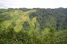
Jhum cultivation, or cut-and-burn shift farming, in Nokrek Biosphere Reserve of Meghalaya.
Political instability[edit]
The state has had 23 state governments since its inception in 1972, with a median life span of fewer than 18 months. Only three governments have survived more than three years. Political instability has affected the state's economy in the past.[95] Over recent years, there has been increasing political stability. The last state assembly elections were held in 2013, after a five-year government that was elected in 2008.[96]
Jhum farming[edit]
Jhum farming, or cut-and-burn shift cultivation, is an ancient practice in Meghalaya.[18] It is culturally engrained through folklores. One legend states the god of wind with the god of hail and storm shook off seeds from the celestial tree, which were picked up and sown by a bird known as do' amik. These were the seeds of rice. The god gave the human beings some of those celestial seeds, provided instruction on shift agriculture and proper rice cultivation practice, with the demand that at every harvest a portion of the first harvest must be dedicated to him. Another folktale is from the Garo Hills of Meghalaya where a man named Bone-Neripa-Jane-Nitepa harvested rice and millet from a patch of land he cleared and cultivated near the rock named misi-Kokdok. He then shared this knowledge with others, and named the different months of the year, each of which is a stage of shifting cultivation.[97]
In modern times, shift cultivation is a significant threat to the biodiversity of Meghalaya.[98] A 2001 satellite imaging study showed that shift cultivation practice continues and patches of primary dense forests are lost even from areas protected as biosphere.[99] Jhum farming is a threat not only for natural biodiversity, it is also a low yield unproductive method of agriculture. It is a significant issue in Meghalaya, given majority of its people rely on agriculture to make a living.[100][101] Shift farming is a practice that is not unique to northeastern Indian states such as Meghalaya, but the issue is found throughout southeast Asia.[102]
Some major media outlets in the state are:[citation needed]
- Meghalaya Times: Meghalaya Times is one of the new entrants in the market and the fastest growing English newspaper in the state. In a short period of time, it has already established large readership across the state.
- Salantini Janera: Salantini Janera is the first Garo language Daily of the state
- Shillong Samay: Shillong Samay is the first Hindi Daily of the State.
- Shillong Times: Shillong Times is one of the oldest English newspapers of the region.
- The Meghalaya Guardian: The Meghalaya Guardian is one of the oldest newspaper of the state.
Over the years there have been several weeklies and Dailies that have come up. To name a few:
- The Tura Times: The Tura Times is the first English Daily which is published out from Tura.
- Salantini Ku'rang: Salantini Ku'rang is the Garo edition of The Tura Times, Pringprangni Aski being the most recent Garo language newspaper to circulate.
- U Nongsaiñ Hima: U Nongsaiñ Hima is the oldest circulating Khasi newspaper in Meghalaya. Established in December 1960, it is now the highest circulated Khasi daily (ABC July – December 2013).
- 'Mawphor': It is one of the daily newspaper circulating in Jowai, Meghalaya.
Weekly Employment Newsletter which is distributed throughout the state:
- Shillong Weekly Express: Weekly Newsletter that was started in 2010.
- Eclectic northeast
References[edit]
- ^ PTI (18 August 2020). "Satya Pal Malik Appointed Meghalaya Governor, to Replace Tathagata Roy". News18. Retrieved 18 August 2020.
- ^ Jump up to:a b c "List of states with Population, Sex Ratio and Literacy Census 2011". Census2011.co.in. Archived from the original on 14 February 2014. Retrieved 9 November 2012.
- ^ "Report of the Commissioner for linguistic minorities: 47th report (July 2008 to June 2010)" (PDF). Commissioner for Linguistic Minorities, Ministry of Minority Affairs, Government of India. pp. 84–89. Archived from the original (PDF) on 13 May 2012. Retrieved 16 February 2012.
- ^ "Definition of Meghalaya in English from the Oxford Dictionaries". Oxford Dictionaries. Archived from the original on 2 April 2015. Retrieved 1 April 2015.
- ^ "Meghalaya | Define Meghalaya at Dictionary.com". Dictionary.reference.com. 14 July 2014. Archived from the original on 2 April 2015. Retrieved 27 February 2017.
- ^ "Fact sheet on meghalaya" (PDF). 10 March 2014. Archived (PDF) from the original on 4 March 2016. Retrieved 12 September 2014.
- ^ Jump up to:a b c Meghalaya Archived 3 September 2013 at the Wayback Machine IBEF, India (2013)
- ^ Jump up to:a b c d e f Arnold P. Kaminsky and Roger D. Long (2011), India Today: An Encyclopedia of Life in the Republic, ISBN 978-0313374623, pp. 455-459
- ^ Jump up to:a b Meghalaya and Its Forests Archived 22 August 2014 at the Wayback MachineGovernment of Meghalaya (2012); Quote – total forest area is 69.5%
- ^ Jump up to:a b Meghalaya Archived 16 July 2014 at the Wayback Machine Planning Commission, Govt of India (May 2014)
- ^ "Collapse of civilizations worldwide defines youngest unit of the Geologic Time Scale". Archived from the original on 18 July 2018. Retrieved 18 July 2018.
- ^ "Meghalaya ecstatic after being etched in geological history permanently". 19 July 2018. Archived from the original on 19 July 2018. Retrieved 21 July 2018.
- ^ Amos, Jonathan (18 July 2018). "Welcome to the Meghalayan Age a new phase in history". BBC News. Archived from the original on 18 July 2018. Retrieved 18 July2018.
- ^ "Newest phase in Earth's history named after Meghalaya rock". Archived from the original on 2 August 2018. Retrieved 19 July 2018.
- ^ "Formal subdivision of the Holocene Series/Epoch" (PDF). Archived from the original (PDF) on 10 July 2018. Retrieved 10 July 2018.
- ^ Hazarika, Manjil (2006). "Neolithic Culture of Northeast India: A Recent Perspective on the Origins of Pottery and Agriculture". Ancient Asia. 1: 25–44. doi:10.5334/aa.06104.
- ^ Glover, Ian C. (1985), Some Problem Relating to the Domestication of Rice in Asia, In Recent Advances in Indo-Pacific Prehistory (Misra, VN. and P. Bellwood Eds.), ISBN 978-8120400153, Oxford Publishing, pp 265-274
- ^ Jump up to:a b SANKAR KUMAR ROY, Aspects of Neolithic Agriculture and Shifting Cultivation, Garo Hills, Meghalaya, Asian Perspectives, XXIV (2), 1981, pp 193-221
- ^ "Upazila background". Tahirpur Upazila.
- ^ Roy, Tirthankar (2012). India in the World Economy: From Antiquity to the Present. Cambridge University Press. p. 202. ISBN 978-1-107-00910-3.
- ^ Jump up to:a b c History of Meghalaya State Archived 24 September 2013 at the Wayback Machine Government of India
- ^ Ammu Kannampilly (31 July 2013). "The Wettest Place On Earth: Indian Town Of Mawsynram Holds Guinness Record For Highest Average Annual Rainfall". Huffington Post. Archived from the original on 23 August 2013. Retrieved 16 August 2013.
- ^ "Basic facts of Meghalaya". Archived from the original on 20 January 2012. Retrieved 13 January 2012.
- ^ "Global Weather & Climate Extremes". World Meteorological Organisation. Archivedfrom the original on 13 December 2013. Retrieved 25 September 2010.
- ^ Jump up to:a b c Birds of Meghalaya Archived 22 January 2015 at the Wayback Machine Avibase (2013)
- ^ Wildlife in Meghalaya Archived 1 March 2014 at the Wayback Machine Government of Meghalaya
- ^ Choudhury, A. U. (2003) "Meghalaya's vanishing wilderness". Sanctuary Asia 23(5): 30–35
- ^ Choudhury, A. U. (1996) "Red panda in Garo Hills". Environ IV(I): 21
- ^ Choudhury, A. U. (2010) The Vanishing Herds: the wild water buffalo. Gibbon Books, Rhino Foundation, CEPF & COA, Taiwan, Guwahati, India
- ^ Choudhury, A. U. (2006) "The distribution and status of hoolock gibbon, Hoolock hoolock, in Manipur, Meghalaya, Mizoram and Nagaland in Northeast India". Primate Conservation20: 79–87
- ^ Zoological Survey of India, Fauna of Meghalaya: Vertebrates, Part 1 of Fauna of Meghalaya, Issue 4, Government of India (1995)
- ^ Choudhury, A.U. (1998) Birds of Nongkhyllem Wildlife Sanctuary & adjacent areas. The Rhino Foundation for Nature in North East India, Guwahati, India. 31pp.
- ^ "World's largest cave fish discovered in India". Animals. 12 February 2020. Retrieved 29 March 2020.
- ^ "Census Population" (PDF). Census of India. Ministry of Finance India. Archived from the original (PDF) on 12 August 2011. Retrieved 18 December 2008.
- ^ Jump up to:a b c d "Population by religion community – 2011". Census of India, 2011. The Registrar General & Census Commissioner, India. Archived from the original on 25 August 2015.
- ^ "Lofty Himalayas notwithstanding, the tribal people of Nartiang in the Jaintia Hills of Meghalaya truly believe that their scenic little hamlet is the "permanent abode" of Goddess Durga. Perched atop a hillock is the more than 600-year old and ancient Durgabari - a simple house made of stones and wood complete with tin roofing. Revered as one of the 51 Shakti Peethas, the temple has been drawing a large number of pilgrims from all over the country on occasion of Durga Puja. - Times of India". The Times of India. Retrieved 20 December 2019.
- ^ https://thenortheasttoday.com/archive/hindu-population-comes-down-in-meghalaya/
- ^ Johnson, R. E. (2010), A Global Introduction to Baptist Churches, Cambridge University Press, ISBN 978-0521877817
- ^ Amrit Kumar Goldsmith, THE CHRISTIANS IN THE NORTH EAST INDIA: A HISTORICAL PERSPECTIVE, Regional Organizer of Churches' Auxiliary of Social Action, Regional Headquarters at Mission Compound, Satribari, Guwahati
- ^ Jump up to:a b ORGI. "C-16: Population by Mother Tongue". www.censusindia.gov.in. Office of the Registrar General & Census Commissioner, India. Archived from the original on 15 August 2018. Retrieved 10 July 2018.
- ^ "Department of Tourism Government of Meghalaya -About Meghalaya". Megtourism.gov.in. 21 January 1972. Archived from the original on 15 May 2009. Retrieved 18 July 2010.
- ^ "The People". Westgarohills.gov.in. Archived from the original on 28 May 2010. Retrieved 18 July 2010.
- ^ Districts of Meghalaya Archived 7 June 2014 at the Wayback Machine Government of Meghalaya
- ^ Jump up to:a b "Meghalaya State Portal". Meghalaya.gov.in:8443. 31 March 2011. Archived from the original on 18 December 2012. Retrieved 9 November 2012.
- ^ "The English & Foreign Languages University, Shillong Campus – Shillong Campus".
- ^ "Meghalaya State Portal". meghalaya.gov.in. Retrieved 17 March 2020.
- ^ "Tathagata Roy resumes charge as Meghalaya governor after long leave". NORTHEAST NOW. 27 January 2020. Retrieved 23 March 2020.
- ^ "See 3rd table set for 2012 in Table 162, Number and Percentage of Population Below Poverty Line". Reserve Bank of India, Government of India. 2013. Archived from the original on 7 April 2014. Retrieved 20 April 2014.
- ^ Jump up to:a b Horticulture Crops Archived 19 November 2014 at the Wayback MachineDepartment of Agriculture, Govt of Meghalaya (2009)
- ^ Rice Archived 21 December 2016 at the Wayback Machine Department of Agriculture, Govt of Meghalaya (2009)
- ^ Food grains Archived 1 March 2014 at the Wayback Machine Department of Agriculture, Govt of Meghalaya (2009)
- ^ Oil Seeds Archived 10 October 2013 at the Wayback Machine Department of Agriculture, Govt of Meghalaya (2009)
- ^ Fibre Crops Archived 9 October 2013 at the Wayback Machine Department of Agriculture, Govt of Meghalaya (2009)
- ^ Demand for power in Meghalaya Archived 13 July 2014 at the Wayback MachineMeghalaya Energy Corporation Limited
- ^ State Planning Archived 4 March 2016 at the Wayback Machine Govt of Meghalaya, pp 129-130
- ^ "Central Electricity Authority". Cea.nic.in. Archived from the original on 9 March 2019. Retrieved 27 February 2017.
- ^ Hydro Power Archived 8 April 2014 at the Wayback Machine Jaypee Group (2010)
- ^ State Planning Archived 4 March 2016 at the Wayback Machine Govt of Meghalaya, pp 154-155 (2010)
- ^ "IIM Shillong Ranked 21st Among Management Institutes". The Shillong Times. 6 April 2017. Archived from the original on 1 August 2018. Retrieved 1 August 2018.
- ^ Philip Richard Thornhagh Gurdon (1914), The Khasis at Google Books, McMillan & Co., 2nd Edition, pp 85-87
- ^ Jump up to:a b Gupta, Susmita Sen (2018), Ethnicity and Development – A Civil Society Perspective from North-East India. In: Journal of Social and Political Sciences, Vol.1, No.2, 297-305. DOI: 10.31014/aior.1991.01.02.20
- ^ "List of NGOs in Meghalaya". http://www.giveindia.org. Retrieved 20 November 2019.
- ^ Jump up to:a b "NGO Darpan". ngodarpan.gov.in. Retrieved 20 November 2019.
- ^ "Enhancing Rural Public Health Capacity in Northeast India". Clinton Foundation. Retrieved 20 November 2019.
- ^ Jump up to:a b c McDuie-Ra, Duncan (19 January 2007). "Civil society organisations and human security: transcending constricted space in Meghalaya". Contemporary South Asia. doi:10.1080/09584930600938040.
- ^ Sachdeva, Gulshan. "India's Northeast: rejuvenating a conflict-riven economy", Faultines. Vol 6, 2000. http://www.satp.org/ satporgtp/publication/faultlines/volume6/Fault6-GSach-F.htm
- ^ Baruah, Apurba K. (2003) Tribal traditions and crises of governance in north east India, with special reference to Meghalaya. Crisis States Research Centre working papers series 1 (22). Crisis States Research Centre, London School of Economics and Political Science, London, UK
- ^ Jump up to:a b c Philip Richard Thornhagh Gurdon (1914), The Khasis at Google Books, McMillan & Co., 2nd Edition, pp 66-75
- ^ Jump up to:a b c d Festivals of Meghalaya Archived 27 May 2014 at the Wayback Machine The Department of Arts and Culture, Govt of Meghalaya (2010)
- ^ Philip Richard Thornhagh Gurdon (1914), The Khasis at Google Books, McMillan & Co., 2nd Edition
- ^ Sudhansu R. Das, Vibrant Meghalaya The Hindu (2008)
- ^ Jump up to:a b "Root Bridges of the Umiam River Basin". The Living Root Bridge Project. 27 April 2017. Archived from the original on 8 September 2017. Retrieved 11 September 2017.
- ^ Jump up to:a b "The Living-Root Bridge: The Symbol Of Benevolence". Riluk. 10 October 2016. Archived from the original on 8 September 2017. Retrieved 11 September 2017.
- ^ "The Living Root Bridge Project". The Living Root Bridge Project. Archived from the original on 5 September 2017. Retrieved 11 September 2017.
- ^ "Why is Meghalaya's Botanical Architecture Disappearing?". The Living Root Bridge Project. 6 April 2017. Archived from the original on 11 September 2017. Retrieved 11 September 2017.
- ^ "Meghalaya rail dream on track". telegrapfindia.com. 30 November 2014. Archivedfrom the original on 8 December 2014. Retrieved 23 February 2017.
- ^ "A mountain railway that existed 125 years ago". Zeenews.india.com. 15 March 2012. Archived from the original on 19 March 2012. Retrieved 9 November 2012.
- ^ "Shillong airport's new terminal to open on Saturday". The Economic Times. 22 June 2011. Archived from the original on 12 April 2012. Retrieved 20 August 2014.
- ^ State Planning Archived 4 March 2016 at the Wayback Machine Govt of Meghalaya, pp 153-154 (2010)
- ^ "Better Air Connectivity for NE Region". Press Information Bureau. 25 April 2013. Archived from the original on 14 January 2014. Retrieved 13 January 2014.
- ^ "Living Root Bridges". Cherrapunjee. Archived from the original on 9 June 2014. Retrieved 11 September 2017.
- ^ "Showing all Waterfalls in India". World Waterfalls Database. Archived from the original on 1 September 2009. Retrieved 20 June 2010.
- ^ List of Sacred Groves in Meghalaya Archived 2 June 2015 at the Wayback MachineGovernment of Meghalaya (2011)
- ^ Eco Destination Archived 9 December 2011 at the Wayback Machine, Department of Tourism, Government of Meghalaya
- ^ Choudhury, A.U. (2008) Balpakram –Meghalaya's heritage IBA. Mistnet 10 (4): 11–13
- ^ Choudhury, A.U. (2010) Nokrek national park – an IBA in Meghalaya. Mistnet 11 (1): 7–8
- ^ Palash Ghosh, India's 2014 Elections: Narendra Modi Says Some Illegal Immigrants From Bangladesh Are Better Than Others Archived 15 July 2014 at the Wayback MachineInternational Business Times, NY Times, (2014)
- ^ V Singh, MHA asks Meghalaya to speed up border fencing work Archived 28 April 2015 at the Wayback Machine Indian Express (16 April 2014)
- ^ "Meghalaya's Congress CM Mukul Sangma too rings alarm on influx of illegal migrants". The Economic Times. 10 August 2012. Archived from the original on 12 August 2012. Retrieved 10 August 2012.
- ^ Meghalaya Violence Statistics, India Fatalities 1994-2014 Archived 29 May 2011 at the Wayback Machine SATP (2014)
- ^ Global Burden of Armed Violence Archived 24 September 2015 at the Wayback Machine Chapter 2, Geneva Declaration, Switzerland (2011)
- ^ SNAITANG, R. (2009), Christianity and Change among the Hill Tribes of Northeast India, Christianity and Change in Northeast India (Editors: Subba et al.), ISBN 978-8180694479, Chapter 10
- ^ "Participatory Planning and Inclusive Governance" (PDF). Megplannnig.gov.in\accessdate=2017-02-27. Archived from the original (PDF) on 11 September 2011. Retrieved 8 November 2012.
- ^ "Official Website of the Election Department, Government of Meghalaya, India". Ceomeghalaya.nic.in. Archived from the original on 22 January 2013. Retrieved 27 February 2017.
- ^ Mazumdar, Culture Change in Two Garo Villages, Calcutta: Anthropological Survey of India (1978)
- ^ Ramakrishnan, P. S. (1992), Shifting agriculture and sustainable development: an interdisciplinary study from north-eastern India, Parthenon Publishing Group, ISBN 1-85070-383-3
- ^ Roy, P. S., & Tomar, S. (2001), Landscape cover dynamics pattern in Meghalaya, International Journal of Remote Sensing, 22(18), pp 3813-3825
- ^ Saha, R., Mishra, V. K., & Khan, S. K. (2011), Soil erodibility characteristics under modified land-use systems as against shifting cultivation in hilly ecosystems of Meghalaya India, Journal of Sustainable Forestry, 30(4), 301-312
- ^ Pakrasi, K., Arya, V. S., & Sudhakar, S. (2014), Biodiversity hot-spot modeling and temporal analysis of Meghalaya using Remote sensing technique, International Journal of Environmental Sciences, Vol 4, Number 5, pp 772-785
- ^ Spencer, J. E. (1966), Shifting cultivation in southeastern Asia (Vol. 19), University of California Press, ISBN 978-0520035171
Bibliography[edit]
- Roy, Hira Lal Deb (1981). A Tribe in Transition. Cosmo.
External links[edit]
 | Wikimedia Commons has media related to Meghalaya. |
Government
General information


